About Yosemite National Park – HD
THE ALL NEW ADVANCED NATIONAL PARK MAPS ARE FOR HIKERS, CAMPERS, ADVENTURE SEEKERS, NATURE LOVERS COMBINED FOR ALL RECREATIONAL ACTIVITIES! NOW COMPATIBLE TO ALL LATEST IOS DEVICES! NEW MAPS – FAST AND EASY PARK MAP OVERLA
THE ALL NEW ADVANCED NATIONAL PARK MAPS ARE FOR HIKERS, CAMPERS, ADVENTURE SEEKERS, NATURE LOVERS COMBINED FOR ALL RECREATIONAL ACTIVITIES!
NOW COMPATIBLE TO ALL LATEST IOS DEVICES!
NEW MAPS – FAST AND EASY PARK MAP OVERLAY!
HAVE FUN ALL THE TIME WITHOUT INTERNET CONNECTION!
NATIONAL PARK OFFLINE MAP COMPRISES ALL THE PARK POI & TRAILS INFORMATION COLLECTED FROM THE NATIONAL PARK SERVICE AND RELEVANT OPEN SOURCES.
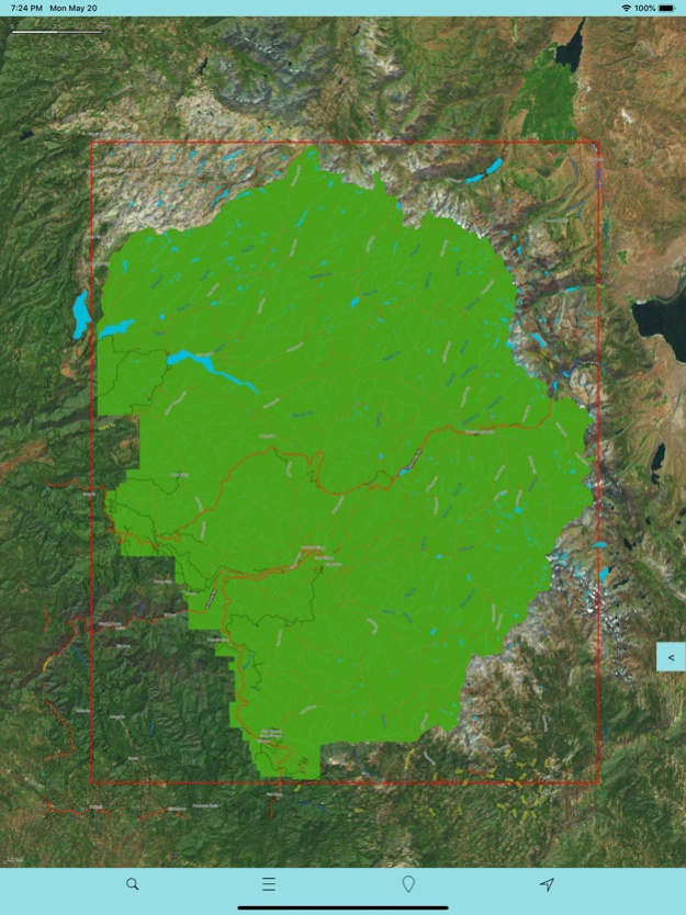
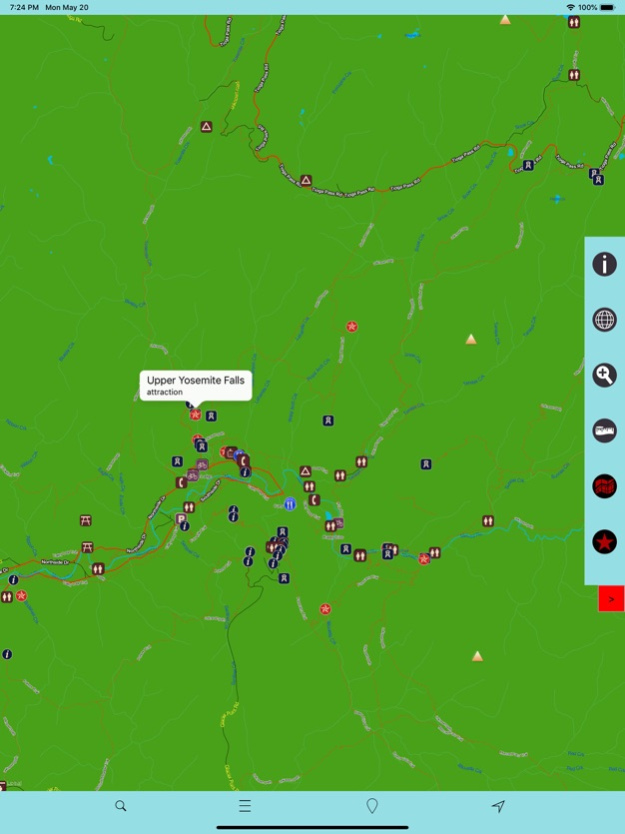
MAP CONTAINS ALL TYPES OF TRAILS, ATTRACTIONS, CAMPGROUNDS, FOOD POINTS, VISITOR CENTRE, PICNIC AREAS, PARKING AREAS, DRINKING WATER, RANGER STATION AND ALL POINT OF INTERESTS AVAILABLE WITHIN THE PARK COVERAGE.
MAP DATA:
INCLUDES ALL LAKES, RIVERS, STREAMS, TRAILS!
ELEVATION CONTOURS WITH 25 METER INTERVAL!
ALL ROADS AND RAILWAYS FROM TIGER!
ALL PARK BOUNDARIES ARE FROM NATIONAL PARK SERVICE!
MAP FEATURES:
GPS FEATURE – SHOWS HEADING AND DIRECTION!
OFFLINE CHART OVERLAY DISPLAY, USE THEM AS LONG AS YOU HIKE, BIKE, WALK, CLIMB OR DO ANY ACTIVITY WITHIN THE PARK!
HIDE OR SHOW CHART OVERLAY TO SEE DIFFERENCE IN ARIEL OR OTHER VIEWS!
HIDE OR SHOW PARK POINT OF INTERESTS!
INSERT UN-LIMITED FAVOURITE MARKERS ON MAP!
ADD 3 PHOTOS TO MARKERS WITH EMAIL AS KMZ OPTION!
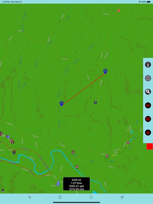
FIND DISTANCE BETWEEN ANY 2 POINTS ON MAP!
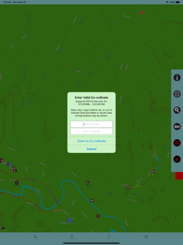
SEARCH LOCAL PLACES OR POINTS (works online)!
SET MAP TYPES CLICKING SINGLE BUTTON!
MAP USER INFORMATION!
THIS APP IS MOST ADVANCED WITH ALL THE NECESSARY TOOLS FOR EASY OFFLINE NAVIGATION. OVERLAY DISPLAY MANAGEMENT ON ALL MAP MODES EITHER ONLINE/OFFLINE IS MORE EASIER FOR HASSLE FREE PARK TOUR. AS THERE WILL BE NO INTERNET IN NATIONAL PARKS, THE OFFLINE CHART MODE IS FASTER AND CONVENIENT FOR UNINTERRUPTED NAVIGATION.
NOTE: All data on map are embedded to match the exact location of features displayed on NPS & reference sources but there may be some difference between the positions of actual objects.
Disclaimer: National Park Offline Map and Points presented are for information and reference purposes only and not for navigation.
We are experts in GIS & IOS Apps development and strive to provide the best products to the end users. Any suggestions from the users of this product are welcome to make the app more useful.
HAPPY NATIONAL PARK RECREATION ALL THE TIME!
Mar 3, 2020
Version 3.5
Support to latest devices and iOS 13 Compatibility.
Previous Versions
Here you can find the changelog of Yosemite National Park – HD since it was posted on our website on 2016-10-18 23:26:53.
The latest version is 3.5 and it was updated on 2024-03-29 19:23:00. See below the changes in each version.
Yosemite National Park – HD version 3.5
Updated At: 2020-03-03
Changes: Mar 3, 2020
Version 3.5
Support to latest devices and iOS 13 Compatibility.
Yosemite National Park – HD version 1.0
Updated At: 2016-01-21
Disclaimer
Official App Store Link
We do not host Yosemite National Park – HD on our servers. We did not scan it for viruses, adware, spyware or other type of malware. This app is hosted by Apple and passed their terms and conditions to be listed there. We recommend caution when installing it.
The App Store link for Yosemite National Park – HD is provided to you by apps112.com without any warranties, representations or guarantees of any kind, so access it at your own risk.
If you have questions regarding this particular app contact the publisher directly. For questions about the functionalities of apps112.com contact us.